


TrackWay - Outdoor Navigation
TrackWay - Outdoor Navigation의 설명
소개
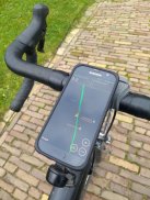
TrackWay는 GPX 트랙을 사용하여 길을 찾을 수있는 실외 내비게이션 앱입니다. Strava에 직접 업로드 할 수있는 기존 트랙을 따르거나 새 트랙을 녹음 할 수 있습니다. 웹 액세스 권한이있는 모든 사람과 라이브 레코딩을 공유 할 수 있습니다. TrackWay는 사이클링 컴퓨터를 완전히 대체 할 수 있습니다.
트랙 교환
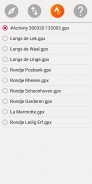
Strava에서 활동을 GPX 트랙으로 다운로드하거나, 클라우드 스토리지를 사용하여 GPX 트랙을 가져 오거나 내보내거나, 소셜 미디어를 통해 GPX 트랙을 공유 할 수 있습니다.
트랙 분석
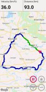
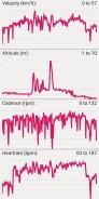
Trackway는 속도, 고도, 기울기, 파워, 케이던스, 심박수 또는 온도를 컬러 라인으로 트랙을 따라 표시 할 수 있습니다.
트랙 만들기
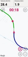
목적지 또는 기록 된 트랙의 시작 지점까지 여러 웨이 포인트를 따라 새 트랙을 만들 수 있습니다.
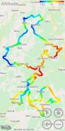
가상 경쟁
진행 상황을 이전 트랙과 비교할 수 있습니다. 경쟁자는지도에서 점으로 표시되고 시차는 빨간색 (뒤) 또는 녹색 (앞)으로 표시됩니다.
센서 연결
TrackWay는 가능한 경우 전화기의 기압계 및 온도 센서를 사용합니다. 속도, 케이던스, 파워 및 심박수를 위해 Bluetooth 및 ANT + 센서에 연결할 수도 있습니다.
배터리 사용량
TrackWay는 낮은 배터리 사용량에 최적화되어 있으며 OLED 화면 (Galaxy S10e에서 측정)의 다크 모드에서 최대 12 시간의 탐색을 제공합니다.
데이터 필드
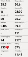
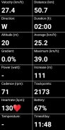
사용 가능한 센서에 따라 TrackWay는 속도, 거리, 평균, 최대, 고도, 증가, 기울기, 파워, 케이던스, 심박수, 지속 시간, 트랙 포인트, 방향, 온도, 시간, 배터리와 같은 데이터 필드를 표시합니다.
TrackWay - Outdoor Navigation - APK 정보
APK 버전: 1.23패키지: nl.dibarto.trackwayTrackWay - Outdoor Navigation의 최신 버전
다른 버전들


 3.79
3.79
동일 카테고리의 앱


